Map axes
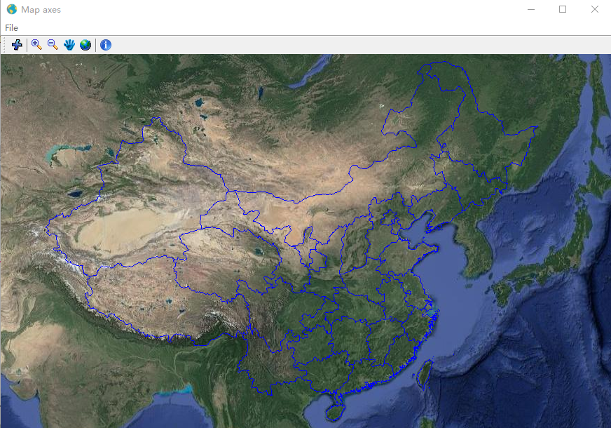
Create a JFrame and add menu, toolbar and a figure which contains a MapAxes object. A web map layer was loaded, and some buttons for map zooming and feature identifing was added.
# coding=utf-8

import java.awt as awt
import javax.swing as swing
from java.awt.event import KeyEvent
from java.io import File
from javax.swing.filechooser import FileNameExtensionFilter
from javax.imageio import ImageIO
import inspect
import os
import sys
import mipylib.miutil as miutil
import mipylib.geolib as geolib
from mipylib.plotlib.figure import Figure

class MainGUI(swing.JFrame):

    def __init__(self):
        super(MainGUI, self).__init__()

        this_file = inspect.getfile(inspect.currentframe())
        self.currentPath = os.path.abspath(os.path.dirname(this_file))
        print self.currentPath

        self.initUI()

    def initUI(self):
        #Add menu bar
        menubar = swing.JMenuBar()
        menu_file = swing.JMenu('File')
        menu_file.setMnemonic(KeyEvent.VK_F)
        menuItem_fileExit = swing.JMenuItem('Exit', None,
            actionPerformed=self.onClick_exit)
        menuItem_fileExit.setMnemonic(KeyEvent.VK_C)
        menu_file.add(menuItem_fileExit)
        menubar.add(menu_file)
        self.setJMenuBar(menubar)

         #Add tool bar
        toolbar = swing.JToolBar()
        toolbar.setPreferredSize(awt.Dimension(300,25))
        self.add(toolbar, awt.BorderLayout.NORTH)
        #Add layer button
        icon = ImageIO.read(File(os.path.join(self.currentPath, 'image/add_layer.png')))
        icon = swing.ImageIcon(icon)
        exitButton = swing.JButton(icon, actionPerformed=self.click_addlayer)
        toolbar.add(exitButton)
        toolbar.addSeparator()
        #Zoom buttons
        icon = ImageIO.read(File(os.path.join(self.currentPath, 'image/zoom_in.png')))
        icon = swing.ImageIcon(icon)
        zoomInButton = swing.JButton(icon, actionPerformed=self.click_zoomIn)
        toolbar.add(zoomInButton)
        icon = ImageIO.read(File(os.path.join(self.currentPath, 'image/zoom_out.png')))
        icon = swing.ImageIcon(icon)
        zoomOutButton = swing.JButton(icon, actionPerformed=self.click_zoomOut)
        toolbar.add(zoomOutButton)
        icon = ImageIO.read(File(os.path.join(self.currentPath, 'image/pan.png')))
        icon = swing.ImageIcon(icon)
        panButton = swing.JButton(icon, actionPerformed=self.click_pan)
        toolbar.add(panButton)
        icon = ImageIO.read(File(os.path.join(self.currentPath, 'image/full_extent.png')))
        icon = swing.ImageIcon(icon)
        fullExtentButton = swing.JButton(icon, actionPerformed=self.click_fullExtent)
        toolbar.add(fullExtentButton)
        toolbar.addSeparator()
        #Identifer
        icon = ImageIO.read(File(os.path.join(self.currentPath, 'image/identifer.png')))
        icon = swing.ImageIcon(icon)
        idenButton = swing.JButton(icon, actionPerformed=self.click_identifer)
        toolbar.add(idenButton)

        #Add figure
        self.fig = Figure()
        self.fig.set_mousemode('pan')
        self.ax = self.fig.add_axes(position=[0,0,1,1], axestype='map', \
            proj='merc', aspect='auto', gridlabel=False, frameon=False)
        self._loadlayers()
        self.ax.axis([80,130,20,50])
        self.add(self.fig)

        self.pack()

        #Set main form
        icon = ImageIO.read(File(os.path.join(self.currentPath, 'image/earth_24.png')))
        self.title = 'Map axes'
        self.setIconImage(icon)
        self.defaultCloseOperation = swing.JFrame.DISPOSE_ON_CLOSE
        self.windowClosing = self.formWindowClosing

    def _loadlayers(self):
        self.ax.webmap(provider='GoogleSatelliteMap')
        self.ax.geoshow('cn_province', edgecolor='b')

    def click_addlayer(self, e):
        fc = swing.JFileChooser()
        filter = FileNameExtensionFilter('shape files', ['shp'])
        fc.addChoosableFileFilter(filter)
        result = fc.showOpenDialog( None )
        if result == swing.JFileChooser.APPROVE_OPTION :
            f = fc.getSelectedFile()
            layer = geolib.shaperead(f.getAbsolutePath())
            self.ax.add_layer(layer)
            self.fig.draw()

    def click_zoomIn(self, e):
        self.fig.set_mousemode('zoom_in')

    def click_zoomOut(self, e):
        self.fig.set_mousemode('zoom_out')

    def click_pan(self, e):
        self.fig.set_mousemode('pan')

    def click_fullExtent(self, e):
        self.fig.onUndoZoomClick()

    def click_identifer(self, e):
        self.fig.set_mousemode('identifer')

    def formWindowClosing(self, e):
        self.dispose()

    def onClick_exit(self, e):
        self.dispose()

if __name__ == '__main__':
    frm = MainGUI()
    frm.pack()
    frm.size = (1000, 650)
    frm.locationRelativeTo = None
    frm.visible = True